Local News
Thursday evening weather brief for Weekend snowstorm

***FRIDAY MORNING UPDATE*** The National Weather Service in Green Bay has issued a blizzard warning for Brown, Outagamie, Winnebago, Manitowoc, Calumet, Kewaunee and Door Counties.
The only real change to the forecast summary is this morning’s model runs are showing even warmer temperatures, not only along the lakefront, but over much of south east Wisconsin. Temps as high as 36 degrees are possible today with widespread 32 degrees father inland. This could impact snow totals. This image is a model grab for later this afternoon.

***ORIGINAL POST BELOW***
Disclaimer… I (KFIZ News Director Doug Raflik) am not a school trained meteorologist. But an immense love of weather has given me a fair amount of weather knowledge over the years.
I’d like to keep this short but it isn’t going to happen. Like I always say, this is a forecast based on model guidance. Models have a tough time with winter storms. As I say what the models are saying, I will explain why it may be misleading. Also, this is pretty much for the immediate Fond du Lac area. But the graphics will show all of Wisconsin.
For starters, here is where we fit in with the current warnings. You can see we are smack dab in the middle of the track as of now if you imagine the storm moving from the southwest to the northeast. Pink is Winter Storm Warning. Iowa is the lucky winner of the Blizzard Warning award for this storm. (Orange)

This is a surface map mid day Friday. Note the surface low pressure of 986 mb. Blue is snow and green is rain. If you look close, you can see rain mixed in with the snow over Lake Michigan. This is because this is the “warm” part of the storm. Wind blows counterclockwise around a low pressure. It’s easiest to imagine the wind flowing in between the lines on this map rather than crossing the lines. Also, the closer the lines are together means the bigger the pressure gradient, or stronger the storm is, and these lines are pretty close so this will mean stronger winds. So you can see the winds in the Fond du Lac area are coming from over Lake Michigan and ultimately from the southeast so this will keep our temperatures relatively warm in the low 30s during much of the storm. I will explain why this is important when I go over snow totals.

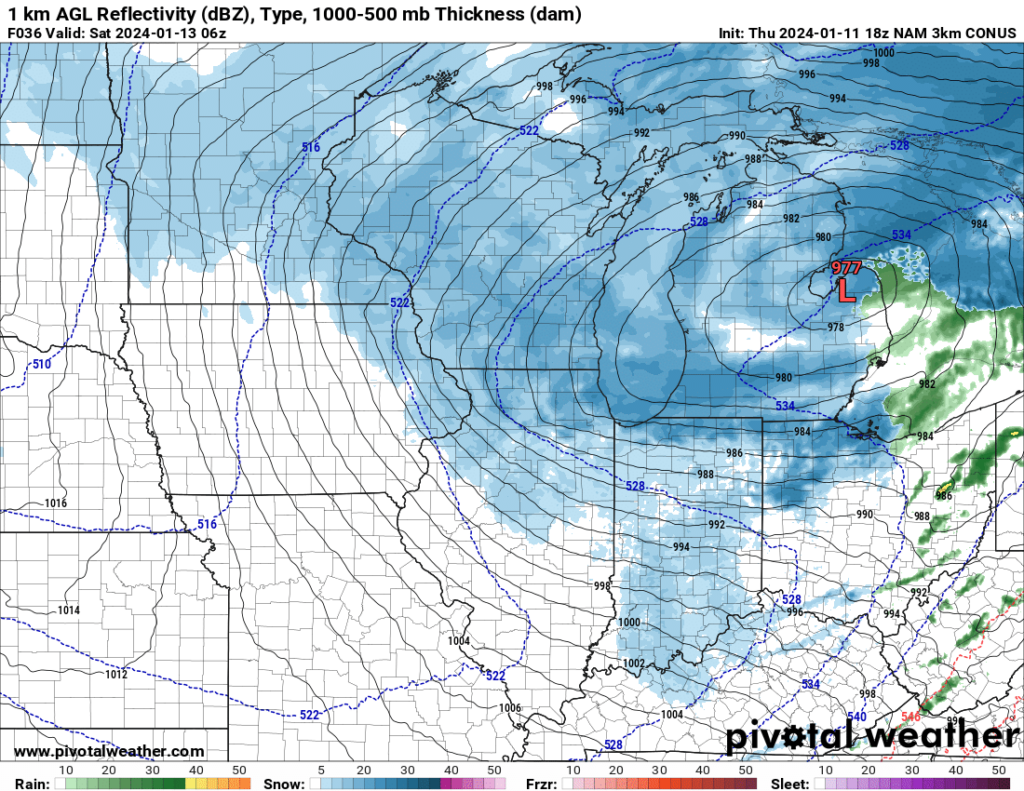
Here is the surface map 12 hours later. You can see the storm is slowly strengthening as it passes to the north east by the pressure now being 977 mb. Lower number = lower pressure = stronger storm. I mention this because the models are showing the storm strengthening. Sometimes if the storm doesn’t strengthen like the models say, severity of the storm will not be as bad.

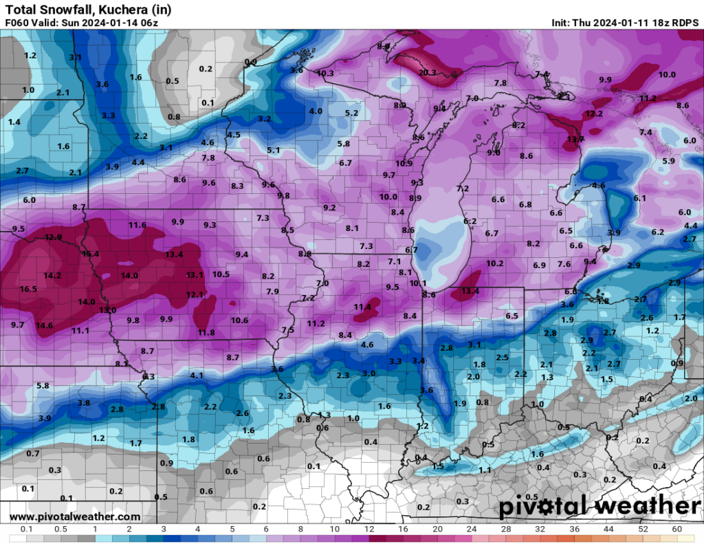
And for the part you are likely waiting for… Snow totals. Here is where it gets tricky and where what I said earlier comes into play. Models showing snowfall totals fail to take certain atmospheric conditions into play. The main point in this instance is the temperature for much of Friday. With it being 32 degrees for most of the day, the snow will be very wet, and some will even melt after it hits the ground. So while the models may show a number of inches falling, that is not a real representation of what you will see on the ground. Take for instance this last snowfall Wednesday night. It was colder so the snow had less water content so it was “fluffier”. Fluffy snow accumulates to more inches even though it has less moisture. Imagine having 1000 dry, fluffy feathers. If you place them in a bucket, it will likely fill the bucket. Now take those same feathers and soak them in water. Put them back in the bucket and you can imaging they would be weighted down and maybe only fill the bucket a quarter of the way. Snow would follow a similar concept. So the snow falling Friday will be wet and will be heavy, therefore will be compacted down upon itself as it accumulates on the ground. Combined with melting of some of the snow and maybe even being mixed with rain near the Lake Michigan area, these next snow totals can be misleading. I looked at a fair sampling of models and will post the two that show the most and the least. Again, this is NOT a crystal ball. If the storm doesn’t strengthen as forecasted or the track shifts to the south or north, this will change these results.


The first model seems to have a good grasp on the warmer air coming off Lake Michigan and keeping the totals lower along the lakeshore, either because some of this falls as rain, or it is a heavier snow that is more compacted as it settles, and then that extra moisture from the lake, i.e. lake effect snow, cools as it moves inland and accumulates higher amounts in the western Sheboygan County, eastern Fond du Lac County area.
Now PLEASE… Don’t go around saying Doug Raflik said we are getting 14.2 inches of snow. This map is the most being forecasted at this time. It is smart to average the high and the low maps and also keep in mind the melting and compacting of this wet snow as it lays on the ground. This equates to lesser amounts on the ground when all is said and done.
Now let’s talk wind. While the wind initially comes from the east and southeast at the start of the storm, as the center of the low passes to our east, winds will switch to the north. The already strong winds are likely to strengthen as the storm strengthens and this is going to cause serious blowing and drifting on mostly east west roads. This will be nearly impossible for county plows to keep up with on all the roads in the area so travel later Friday into Saturday will be very dangerous. Please have an emergency kit in your vehicle if you have to go out and make sure your phone is fully charged should you need to call for help.
Winds Friday evening into the overnight hours will be consistently be blowing at 20-30 mph with gusts up to around 40.
If this forecast changes drastically over the next 24 hours, I will make changes at the top of this article.
Good Luck. 🙂


