


Local News
Sunday evening update to potential severe weather outbreak for Monday, April 28
We are now about 24 hours from either a potential severe weather outbreak, or one of the biggest trolling moments Mother Nature has ever played on us.
As we’ve mentioned in the last update, weather forecast models are painting all the colors of the severe weather palette, however storms look to have a hard time forming due to the cap. Read this morning’s outlook to learn about the cap if you haven’t yet.
A tool we have tonight that we didn’t have last night is to compare how last night’s models predicted what was going to happen tonight, as this is close to the same weather circumstances that will be in the area tomorrow night.
So how did last night’s models do? Not so good.
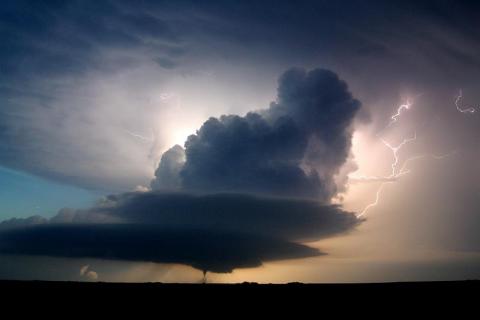
Three supercell storms, all producing tornadoes, formed in west central Nebraska.
With this real time information of what was happening, we went back to last night’s models to see what they thought would happen tonight. The two main short range models said nothing was going to happen where these storms had formed. So that tells us that the models, even though very consistent in their forecasting a lack of storms, really didn’t have a good grasp on this weather system.
And the models aren’t the only ones without a good grasp of what will happen. Most of the forecasts from those like the National Weather Service, private forecasting entities, and media outlets (Including us) have wording such as “but” and “however” because we really don’t know either.
What we do know is the potential is absolutely there for very strong storms with tornadoes, hail and strong winds.
Taking todays events and looking at what models have to say about Monday, we can deduce that storms are likely to happen, but they are likely to stay isolated during the start of the “outbreak” in Iowa, but as things move to our area, we could see more of a quasi or broken line of storms, any of which have the potential to put out a brief tornado, hail and/or wind.
In Minnesota, storms are a bit more widespread at the start, around 7-10 p.m.
The 7-10 pm time frame is when models show the biggest tornado potential of any storms that do form in the tri state area of northeast Iowa, south east Minnesota and western Wisconsin. There is plenty of spin left over however, as storms move into our area, mostly after dark.
So to sum it up, this is one you will need to pay close attention to later tomorrow night if and when storms move into the area. Models still have a hard time saying this will be an outbreak of severe storms while the atmosphere is saying “hold my beer… I have something to show you.”
It’s also worth noting that there is a chance of some showers and storms earlier in the day, however these are not the storms we will be most concerned with.
As chance would have it, NOAA’s Weather Radio for southeast Wisconsin will be down for maintenance tomorrow, so if that’s your go to for receiving warnings, you will need to find an alternate method. Make sure phones are charged by tomorrow afternoon to get warnings on them, and have your favorite media outlet on (Like KFIZ).
KFIZ Facebook page will have up to the minute watches and warnings as well as some short, real time analysis of storms as they approach the area.