


Local News
Heat wave in place over midwest… but why?

A heat advisory goes into effect for Fond du Lac County at 1 PM today, Monday, August 26, 2024, and runs through 8 PM tonight with an excessive heat warning in effect during the same time period for counties just to our west and south.
An Excessive Heat Watch will be in effect for Tuesday for all of southeast Wisconsin, although cloud cover from storms approaching from the west could prevent some areas from reaching dangerous heat levels.
Highs Sunday reached 87 degrees with a heat index of 95 but Monday will climb even higher with highs in the low 90s and a heat index value exceeding 100 degrees.
The heat is a result of what we call a ridge in the atmosphere, or a big bump in the jet stream that is extending to our north. Imagine looking at a map of the United States and the jet stream is a huge highway that travels from west to east. Usually the Jetstream has small bumps and dips, as it traverses along the middle of the country, but a ridge would have the highway dip into the southwest states and then turn north all the way into Canada before coming back down over the New York area. The jet stream often helps separate air masses with warmer air to the south of it and cooler air to the north, so with the jet stream well to our north right now, this is allowing the hot humid air usually positioned along the southern gulf states, to extend north all the way to the Canada / US border.
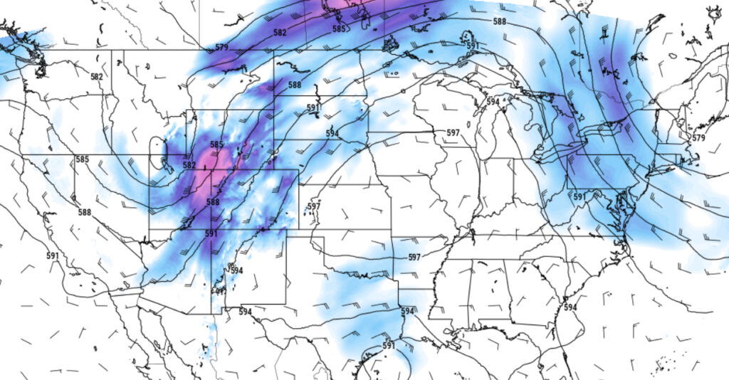
These ridges, as their called, often have warm air aloft as well, which inhibits the formation of storms one often associates with hot humid days. That is until the western portion of this bump in the jet stream moves over, allowing cooler air to return to the area. This looks to happen Tuesday sometime when we could see an area of strong to severe storms come through. Monday, that area of storms will be in the South Dakota region moving into Minnesota overnight. There, They’re expecting some severe weather later Monday and into Monday night.
As of Monday morning, models are in disagreement with storm placement tomorrow as one is forecasting two rounds of storms to move through the area. One around mid morning and another in the evening. Another model has storms mostly missing us to the north. As always you can watch KFIZ .com and KFIZ Facebook for any updates with watches or warnings that may come with those storms.
After the storms pass, we return to more seasonable temperatures Wednesday with daytime highs falling to around 80.