


Local News
Powerful Spring storm system pounds eastern third of country
It’s gonna be a wet and windy day Wednesday, April 2, 2025, for the Fond du Lac County area as a large low pressure storm system makes it’s way into the eastern third of the country.
Precipitation started as snow for us last night with pretty big flakes at a respectable rate. Snow quickly accumulated up to around an inch before warmer air being pushed up on southerly winds out ahead of the low pressure, warmed things up to just above freezing, turning those flakes to rain.
That rain will continue over the area today with a couple rumbles of thunder mixed in. We look to be positioned just north of the greatest instability where any severe weather could form, yet just south of
the colder temperatures where the precipitation falls as snow in Minnesota and far northern Wisconsin.
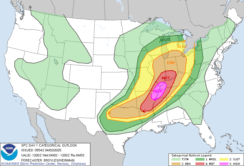
This system looks to really pack a punch to southern states where the Storm Prediction Center has given the almost elusive high risk category for severe weather to the Mississippi Valley over southern Illinois down into Arkansas where tornadoes, high winds and hail reports are expected in high numbers there.
This system is moving at a fairly good clip and should be through the area by tonight with a cold front moving through on the backside of the system.
This sets up a pleasant Thursday with a high near 50, although it will be a little breezy with the pressure gradient pretty strong between the departing low and approaching high pressure.
That nice weather spreads into Friday but we start to see the effects of the next system Friday night into early Saturday when rain will move up from the passing system to our south.
High pressure again follows that system bringing dry weather for the middle part of the weekend, and as of now, a small clipper system may develop just to our northwest Sunday night that could give us a dusting of snow.